


A Frost Advisory is in effect from 7 a.m. Monday for Lapeer, Livingston, Macomb, Oakland, Sanilac, St. Clair, and Washtenaw counties. Damage to sensitive plants is possible, so cover them up to protect from the cold temperatures.
Watch the forecast below
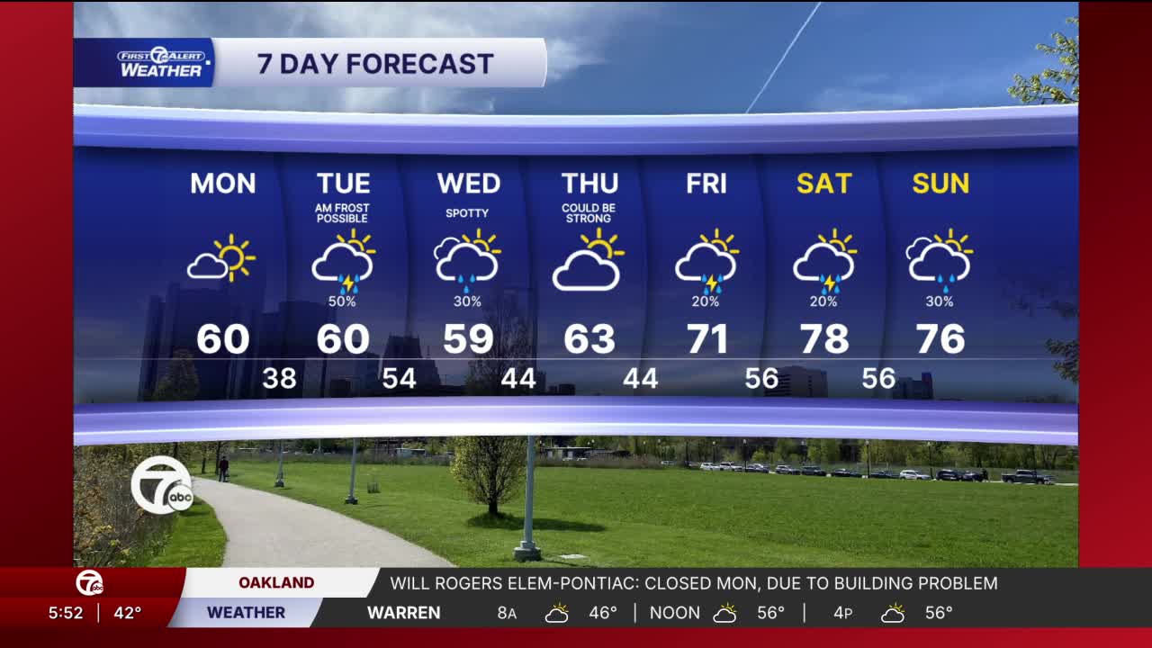
A chilly start gives way to a fairly comfortable afternoon across Metro Detroit. Highs will climb into the upper 50s to around 60 degrees for most communities, though lakeshore areas near Port Huron and Port Sanilac stay noticeably cooler in the upper 40s thanks to the north wind off Lake Huron. Expect a mix of sun and clouds through the day with light north winds around 5 to 10 mph.
Temperatures drop quickly again tonight with another round of frost possible, especially north and west of Detroit where lows dip into the low to mid 30s. Urban areas stay a little milder near the upper 30s. Skies remain partly cloudy with light east-northeast winds around 5 to 10 mph. Sensitive plants may still need protection in some neighborhoods by late tonight and early Tuesday morning.
Tuesday starts with some sunshine and cool temperatures in the 40s before clouds steadily increase during the afternoon. Highs recover into the upper 50s, but the second half of the day turns noticeably grayer. It stays dry for most daylight hours, making the morning and early afternoon the better window for outdoor plans.
Rain chances hold off through much of Tuesday, but showers become more likely during the evening and overnight hours. After sunset, moisture increases quickly with rain chances climbing from scattered showers during the evening to widespread rain potential late Tuesday night. The steadiest rain looks most likely closer to and after 10 PM.
After the chilly stretch, temperatures begin a steady warm-up heading into the second half of the week. Wednesday stays cool with scattered morning showers and highs near 60, but sunshine returns Thursday with highs back into the low 60s. By Friday and the weekend, Metro Detroit could be looking at the warmest weather in weeks with highs surging into the 70s and a few chances for pop-up showers or thunderstorms. Saturday currently looks like the warmest day, approaching the upper 70s.
Monday: Mostly sunny. Highs in the upper 50s, to near 60°. Winds: NNW 5-10 mph.
Tonight: Partly cloudy with areas of frost possible. Lows in the upper 30s to near 40°. Winds: ENE 5-10 mph.
Connect with 7 First Alert Meteorologists on Facebook and X:
Facebook: Dave Rexroth , Hally Vogel, Marisa Woloszyn, Mike Taylor
