
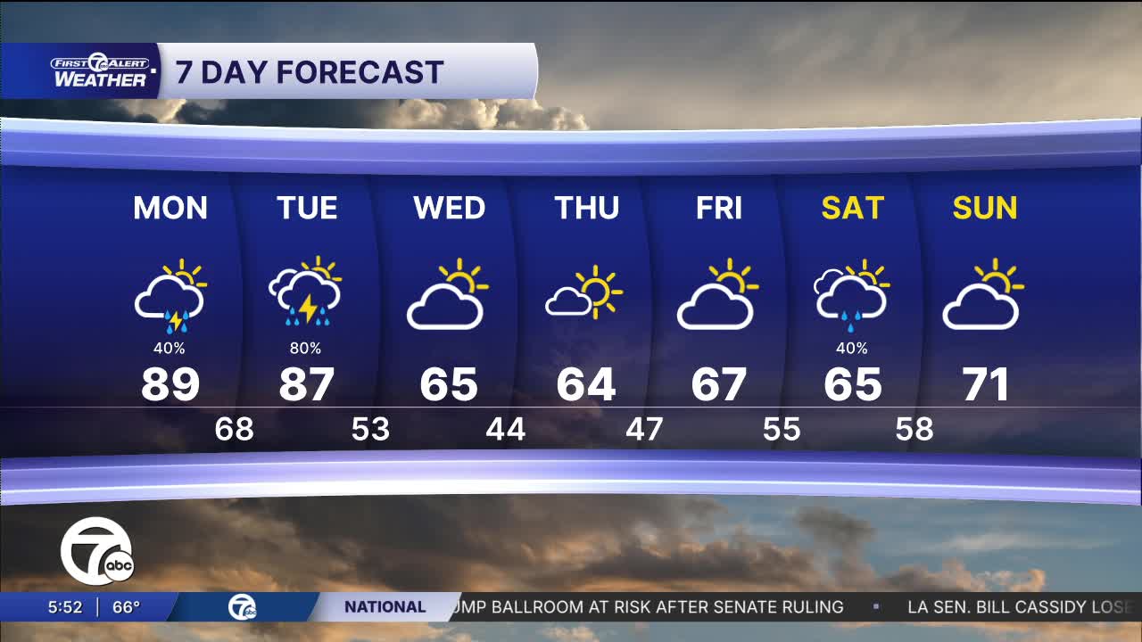


A warm and quiet start to the day with sunshine early and temperatures quickly climbing through the 70s. By lunchtime, clouds begin to increase, but most of the daytime hours stay dry. Afternoon highs push the upper 80s with a summer-like feel across Metro Detroit. A good day to get outside, but it’ll feel noticeably warmer by late afternoon.
Watch the forecast below
Rain chances stay very low through the early afternoon before increasing later in the day. The better opportunity for showers and thunderstorms arrives between roughly 5 PM and 8 PM, when coverage becomes more scattered to likely. A few storms could linger into the overnight hours, though activity becomes more isolated after midnight.
A few stronger storms are possible this afternoon and evening, with damaging wind gusts appearing to be the primary concern. While isolated hail, localized flooding, and even a brief tornado can’t be completely ruled out, those threats currently look lower and more limited. Not everyone will see severe weather, but it’s worth staying weather aware later today.
Warm and breezy tonight with temperatures only falling into the mid to upper 60s across Southeast Michigan. Passing showers and a few thunderstorms remain possible overnight, especially during the evening hours. Winds stay out of the south-southwest at 10 to 20 mph, keeping the air mild and humid through the night.
Tomorrow starts warm and mostly cloudy with temperatures already well into the 70s by mid-morning. Winds increase through the afternoon as highs climb into the mid 80s. Scattered thunderstorms are expected to develop later in the day, especially after 4 PM, and some storms could once again become strong.
After the warm and stormy stretch, cooler air settles back into the Great Lakes by midweek. Highs fall back into the 60s Wednesday through Saturday with a mix of clouds and occasional sunshine. Another chance for showers arrives Saturday before temperatures begin warming again heading into Sunday.
Today: Sun and clouds with highs near 89 to start. Storms will push through during the afternoon and could be strong to severe. Winds: SSW 15-25 mph
Tonight: Mostly cloudy skies with lows near 68. Winds: SSW 10 - 20 mph.
Tuesday: Sun and clouds with highs near 87 to start. Storms will push through during the afternoon and could be strong to severe. Winds: SSW 15-25 mph
Connect with 7 First Alert Meteorologists on Facebook and X:
Facebook: Dave Rexroth , Hally Vogel, Marisa Woloszyn, Mike Taylor
