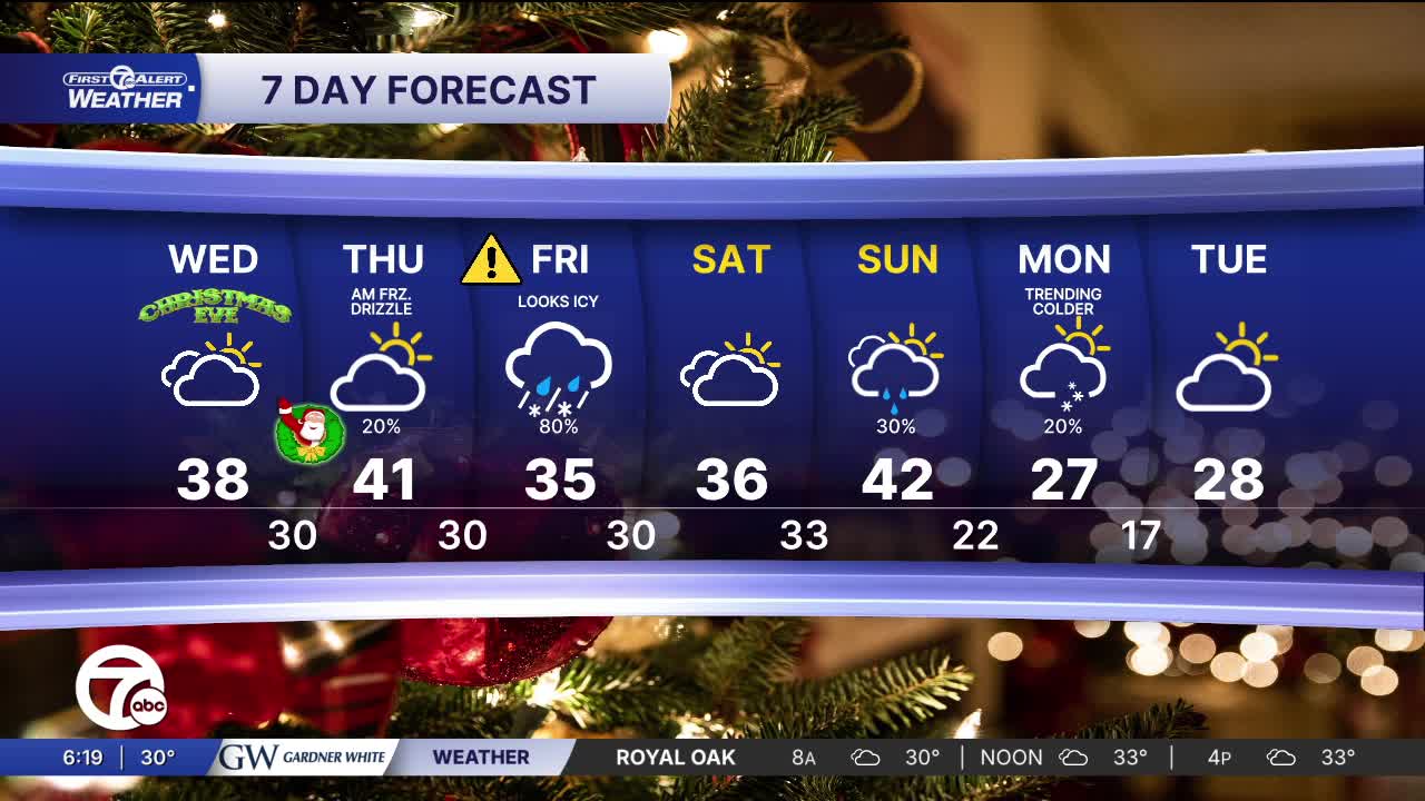
WeatherForecastTodays Forecast

Metro Detroit Weather: Mild and quiet for the holidays

Metro Detroit Weather: Soggy start with a high in the mid 40s
Posted
and last updated

Metro Detroit will notice a fairly gray Winter day with mostly cloudy skies and mild temperatures. Expect highs climbing into the mid 40s this afternoon under gradually clearing skies, with only a small chance of light precipitation. Tonight will turn colder with lows dipping into the upper 20s since skies clear up some.

Watch the full forecast

Metro Detroit Weather: Soggy start with a high in the mid 40s

Expect classic Winter weather on Christmas Eve in Detroit — cool and predominantly cloudy with temperatures holding in the mid-30s to around 38° during the day and falling into the upper 20s to around 32° at night. The sky will stay overcast and there’s only a small chance of light precipitation later in the day, so you’ll likely see a dry, chilly holiday vibe with no major storms moving through. It won’t be a snowy, picture-perfect Christmas Eve, but it will feel like a true December day — great for last-minute holiday errands or cozy indoor gatherings.

Another "milder-than-usual" Christmas here in Detroit with early winter drizzle and clouds than a classic snowy holiday. Highs should climb into the upper 30s to low-40s during the day with mostly cloudy skies, and there’s a good chance of light rain or drizzle at times, especially when temperatures are above freezing. By the evening the clouds stick around with temperatures falling back toward the 30s under mostly cloudy skies. Overall, it’ll feel unseasonably mild for late December with a wet, gray Christmas Day rather than a white one — so enjoy the relatively warm holiday, but plan for damp conditions.

Christmas - Last 10 Years.png
Highs of Christmas Past

If you were hoping for snow on the ground, historically Detroit has about a 35% chance of at least an inch of snow on the ground for Christmas based on long-term averages but this year keeps the milder theme going, which has been common over the last 10 years.

The Day to Watch

Friday is shaping up to be the most troublesome day of the week weather-wise across Metro Detroit with a strong storm system moving through the Great Lakes that will bring significant precipitation and an elevated ice risk as temperatures hover right around the freezing mark. The forecast is inline for rain and freezing rain in the morning, especially before midday, as warmer, moist air overspreads the region just ahead of the colder air behind a cold front. That means wet road surfaces could turn icy quickly overnight into the early morning, with untreated bridges and side streets especially vulnerable to slick spots and ice.

The core of the storm will likely feature a mix of rain and freezing rain with the potential for ice to accumulate where surface temperatures remain below freezing for a prolonged stretch. As the day warms slightly, that ice threat should ease and transition to just rain through the afternoon before tapering off. Even so, travel conditions Friday morning could be hazardous, with slippery roads and sidewalks in places — especially in lower-traffic residential areas that don’t get treated as quickly.

Overall, think wet, gray conditions with a tricky start to the day with an ice risk that will demand cautious driving and extra travel time. We'll keep you updated since small changes can decide whether precipitation falls as rain, freezing rain, or even a little snow.

The Set Up - Mike.png
The set up

Today: A soggy start followed by a mostly cloudy warm up with highs in the mid 40s. Winds: WSW 10-15 mph.

Tonight: Partly cloudy skies with enough clearing to drop the temps near 28. Winds: NW 5-10 mph.

Wednesday: Mostly cloudy skies again with temps near 38. Winds: SE 5-10 mph.

Connect with 7 First Alert Meteorologists on Facebook and X:

Facebook: Dave Rexroth , Hally Vogel, Marisa Woloszyn, Mike Taylor

X: Dave Rexroth , Hally Vogel, Marisa Woloszyn, Mike Taylor