


An Extreme Heat Watch has been issued for all of southeast Michigan from Tuesday to Thursday. Heat index values will be 105°-109°. Stay cool during this time. Not everyone has air conditioning, so check on your family, friends, neighbors, and pets to make sure they're staying cool.
Watch the forecast below
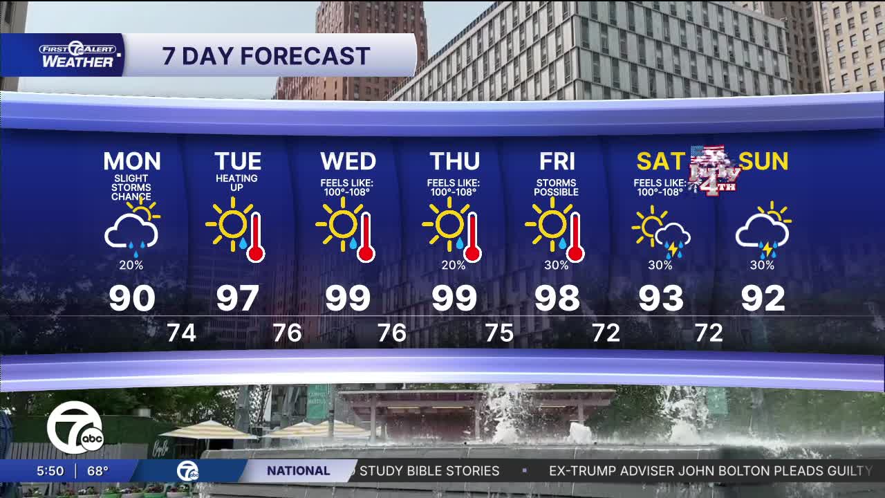
Heat is building back into southeast Michigan today after a comfortable start to the morning. Afternoon temperatures will climb to around 90 degrees for much of Metro Detroit, with the warmest readings west and southwest of the city. Humidity also increases through the day, making it feel a bit warmer than the thermometer suggests. Most neighborhoods stay dry, but an isolated shower or thunderstorm can’t be ruled out today, especially west of the city.
The hottest part of the day arrives between about 2 and 7 PM, when the combination of heat and humidity pushes the “feels like” temperature into the lower and middle 90s. If you’re spending time outside, take frequent breaks, stay hydrated, and try to limit strenuous activity during the afternoon. Conditions will become much more comfortable later this evening as temperatures slowly fall after sunset.
This is just the beginning of a prolonged stretch of dangerous heat. An Extreme Heat Watch is in effect beginning Tuesday and lasting through Thursday night as temperatures climb well into the 90s with very warm nights offering little relief. Heat impacts tend to build over several days, so now is a good time to prepare by checking your cooling plans and looking out for neighbors, pets, and anyone without reliable air conditioning.
Tuesday will be even hotter than today. Afternoon highs surge into the mid and upper 90s across southeast Michigan, with Detroit expected to reach around 97 degrees. Combined with increasing humidity, heat index values will approach or exceed 100 degrees in many locations. Southwest winds will add to the summer feel, making this one of the hottest days we’ve seen in several years.
The heat peaks Wednesday and Thursday with highs near 100 degrees and heat index values between 100 and 108. Those will likely be the most uncomfortable days of the stretch. By Friday, a few thunderstorms become possible as a front approaches, although temperatures will remain in the upper 90s. That front should finally knock temperatures down a bit for the weekend, with highs settling into the lower 90s and a few additional chances for scattered showers and thunderstorms.
Today: Partly sunny with a slight shower chance north. Highs in the upper 80s to low 90s. Winds: S 5-10 mph.
Tonight: Partly cloudy with lows in the mid 70s. Winds: Light
Tuesday: Mostly sunny with highs in the mid to upper 90s, near 100°.
Wednesday: Mostly sunny with highs in the mid to upper 90s, near 100°.
Connect with 7 First Alert Meteorologists on Facebook and X:
Facebook: Dave Rexroth , Hally Vogel, Marisa Woloszyn, Mike Taylor
