


Expect light snow Tuesday morning. There is a slight chance for light freezing rain or drizzle mostly after the morning rush. Snow totals should be under an inch south of I-94, around an inch north of I-94 to I-69 and up to 2" in the thumb. Another system hits us starting Tuesday evening. It will be a mix of snow and rain with snow totals through Wednesday night more than the first storm.
Watch the storm details here:
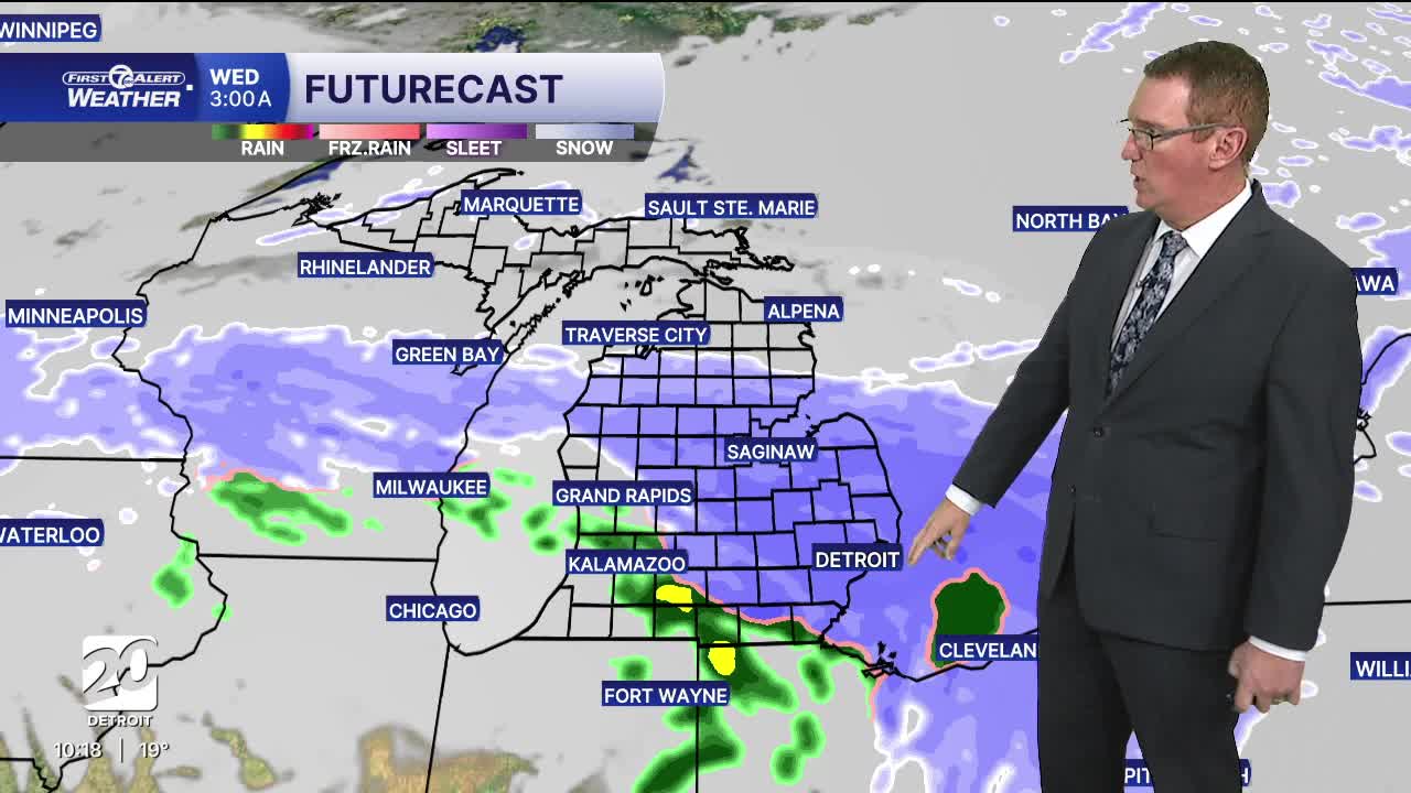
Another system will be on the heels of Tuesday's snow and will bring more overnight and into Wednesday. Snowfall totals are a bit uncertain because we could get snow or a rain-snow mix depending on temps and timing. There's also a brief window for sleet to mix in, leading to ice accumulation. As of now, areas north of M-59 will likely have all snow Tuesday night into Wednesday, with a few inches of accumulation. South of M-59 will likely start with snow and then switch to rain or sleet.
There are growing signs that Detroit is heading into a colder pattern later this week. Forecast trends show arctic air settling back into the Great Lakes, keeping daytime highs mostly in the 20s and pushing overnight lows down into the teens, with wind chills making it feel even colder at times. This setup doesn’t necessarily scream constant snow, but it does lock in cold enough air that any snow or flurries that do occur will stick around longer. December's start is shaping up to be a true mid-winter pattern — colder than normal, more persistent cold, and a backdrop that keeps snow chances alive even with weaker systems.
So this all means that our chances for a White Christmas in Detroit are going to be higher than normal this year. The typical chance based on the last 30 years is 34.7%.

Tonight: Mostly cloudy. Lows in the mid teens and then temps will slowly rise toward sunrise. Winds: SW 5-15 mph.
Tuesday: Snow returns to the area in the morning, which could make the roads slick. 1" - 2" of snow is possible north of Detroit with less than an inch around Detroit south. Highs reach the low 30s to mid 30s with 35° in Detroit. Winds: SW 15-25 mph
Wednesday: A wintry mix of snow and rain is expected. Highs will climb into the upper 30s with 39° in Detroit. Snow totals should be highest northwest of Detroit around Pontiac, Lpeer, and Livingston County. These areas could end up with 3"-5" from Tuesday evening through Wednesday night. Around Detroit and south snow totals during this time should be closer to 1"-2" because of rain mixing in. Winds: W 10-20 mph.
Connect with 7 First Alert Meteorologists on Facebook and X:
Facebook: Dave Rexroth , Hally Vogel, Marisa Woloszyn, Mike Taylor
